ISRO’s Chandrayaan 2 identifies craters that may have water after mapping 4 million square kilometres of the Moon in its first year

- The Indian Space Research Organisation’s (ISRO) Chandrayaan 2 has been in orbit around the Earth for a year now.
- The space agency released some of the discoveries that the orbiter has already made, like identifying areas on the Moon where water could be present.
- Here are six of the main discoveries by ISRO’s Chandrayaan 2 orbiter in the last one year.
The orbiter was successfully injected into orbit on August 20. The eight the eight instruments onboard have been scouting the lunar surface for information and clues that could set the stage for further moon exploration.
Even though the space agency did not share how much data was sent back to Earth, nearly half of it was from the Solar X-ray Monitor (XSM) and Chandrayaan-2 Large Area Soft X-ray Spectrometer (CLASS).
According to ISRO, the orbiter has enough fuel to continue its orbit around the Moon for another seven years. The data that it has collected so far will be made public by year-end.
Here are the highlights of the discoveries that Chandrayaan 2 's orbiter has made so far:
Chandrayaan 2’s Terrain Mapping Camera took photos of nearly 4 million square kilometres of the Moon’s surface
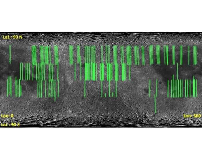
The Terrain Mapping Camera - 2 (TMC -2) completed 220 orbits of the Moon and took images of nearly 4 million square kilometres of its surface.
ISRO’s Orbiter High-Resolution Camera scouts future landing sites for Moon missions
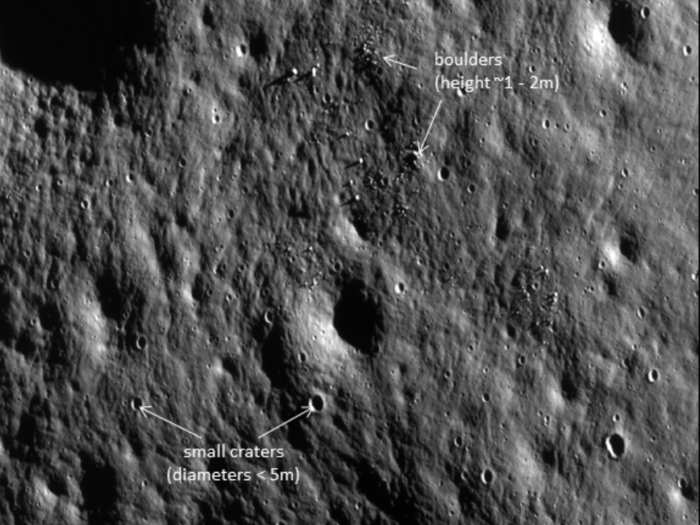
In its time around the Moon, the Orbiter High-Resolution Camera (OHRC) took 22 photos covering 1056 square kilometres. A part of its purview is characterising landing sites on the Moon for future missions, which means looking for boulders, mapping the elevation, and other factors to help navigate landing on the lunar surface.
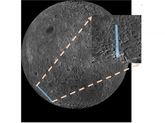
Chandrayaan 2’s DFSAR finds lunar craters that may contain water
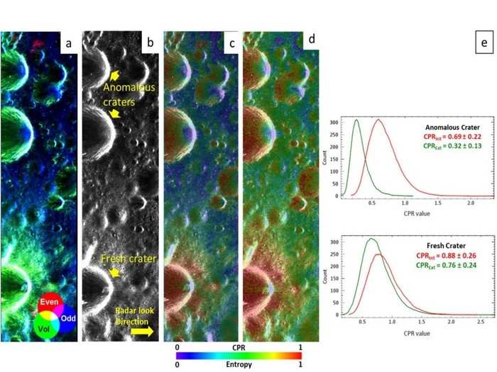
According to ISRO, secondary craters within the larger Peary crater have the right values to ‘ideal candidates for bearing water-ice’. Other craters that have the same circular polarisation ratio (CPR) shown above are likely newer and won’t be home to any form of water.
OHRC took pictures of where Vikram crashed onboard the Chandrayaan-2 orbiter
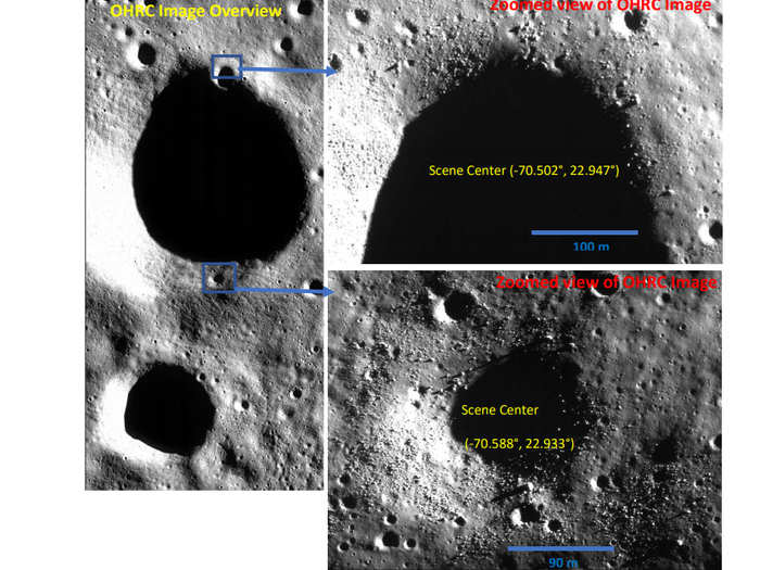
Chandrayaan-2’s lander, Vikram, crash-landed on the Moon after detaching from the orbiter. Along with the National Aeronautics and Space Administration’s (NASA) Lunar Reconnaissance Orbiter (LRO), the OHRC also took a picture of the landing site in March this year.
Chandrayaan 2’s CLASS finds aluminium and calcium on the far side of the Moon
Chandrayaan-2 Large Area Soft X-ray Spectrometer (CLASS) was watching closely when the second-largest solar flare of the year occurred on May 29. As the orbiter flew over the southern farside highlands, it caught a glimpse of aluminium and calcium down below.
Not much is known about the far side of the Moon. All of the samples that were brought back during the Apollo missions were from the near side. “However, we know today that the highland compositions are more diverse than what is represented in the returned samples,” said ISRO.
TMC-2 captures hard to detect lunar lobate scarp that may have formed 1.1 billion years ago
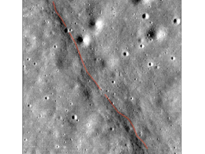
Lunar lobate scarps — newly formed small landforms, which are long angle thrust faults — are not easy to detect because of their small size. TMC-2 discovered one such scrap in the Mare Fecunditatis region on the Moon.
The image indicates that the length of the scarp is 1416 metres. The average relief variation across the scarp is 24 metres. According to ISRO, This lobate scarp could have been formed in the Copernican period, 1.1 billion years ago.
READ MORE ARTICLES ON
Popular Right Now
Advertisement