Satellite and aerial images show how a derecho destroyed 10 million acres of Iowa's corn crops
Advertisement
Michelle Mark
Aug 14, 2020, 02:17 IST
In this aerial view from a drone, corn plants are shown pushed over in a storm-damaged field on August 11, 2020 in Tama, Iowa.Daniel Acker/Getty Images
The derecho that ripped through the Midwest left field after field of damaged corn crops in Iowa, and photos and satellite images have revealed the extent of the destruction.
Iowa officials have estimated that at least 10 million acres of corn and soybean crops were damaged or destroyed by the violent windstorm.
The derecho even crushed massive grain silos, leaving the metal structures crumpled over the spilled grain.
Industry experts have told media it's too soon to tell how much of the state's crops will be lost from the damage — the state was expected to fill 18% of the nation's total corn production this year.
Advertisement
Images taken from the sky and from space show the extent of the damage to Iowa's crops after a violent windstorm known as a derecho pummeled the Midwest on Monday.
The winds killed at least two people, knocked out power, crushed grain silos, and flattened field after field of corn and soybeans.
Iowa Gov. Kim Reynolds has estimated that 10 million acres were damaged or destroyed by the derecho. That's roughly 43% of Iowa's 23.4 million acres that were seeded this spring with corn and soybeans, Radio Iowa reported.
In this aerial image from a drone, corn and soybeans spill from damaged grain bins at the Heartland Co-Op grain elevator on August 11, 2020 in Luther, Iowa.Daniel Acker/Getty Images
The crop damage was so widespread that the fields of crushed corn stalks could be seen from space.
These back-to-back images from NASA Worldview show what the state of Iowa looked like before the derecho and immediately after, with vast expanses of cropland around the Des Moines area appearing flattened.
Advertisement
The Washington Post, which also published the satellite images, reported that the core of the heavy winds may have stretched 30 to 50 miles wide.
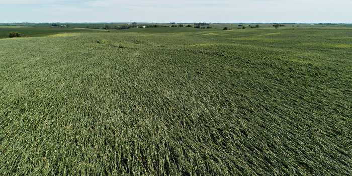
Striking images from the ground also showed the knocked-down corn plants in field after field.
Corn plants are shown pushed over in a storm-damaged field on August 11, 2020 in Tama, Iowa.Daniel Acker/Getty Images
Videos of the derecho showed powerful winds ripping through the corn fields and pushing down the stalks.
Industry experts told the Associated Press it was still too soon to gauge how much of the state's crops would be lost this year, and much of it depends on whether the majority of the crops were simply bent over by the wind, or fully broken and dead.
Iowa's corn production is a roughly $10 billion industry, and the state was expected to produce 18% of the nation's 15.3 billion bushels to be harvested this year.
Advertisement
In many of the Iowa corn fields, the stalks were in their final stages of development when the derecho hit. That means the plants were already filling ears of corn with kernels when the winds struck on Monday, the Associated Press reported.
A spokesperson for the Iowa Agricultural Department told The Post it'll likely take at least a week to assess the true damage, since some of the corn may yet be able to stand back up, though some may be irreparably broken.
NewsletterSIMPLY PUT - where we join the dots to inform and inspire you. Sign up for a weekly brief collating many news items into one untangled thought delivered straight to your mailbox.


 Next Story


 Stock indices surge as Sensex-Nifty start trading week on positive note
 KL Rahul-led LSG concede biggest defeat margin by runs in IPL against KKR
 Indian markets could recover on Monday but earnings, global cues will decide the rest of the week, say experts
 Top temples to visit in India you must visit atleast once in a lifetime
 Top 10 adventure sports across India: Where to experience them in 2024
