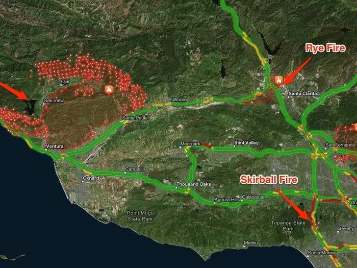
The fires have prompted the evacuation of close to 200,000 people and burned over 100,000 acres as of Thursday.

As of Thursday morning, the Thomas Fire is burning 96,000 acres, and has destroyed at least 150 structures out of approximately 12,000 threatened. Firefighters have only contained 5% of the blaze as high winds continue to whip the fire.
Officials ordered further evacuations in the city of Ojai as high winds pushed the fire closer to populated areas. A woman's body was found near a vehicle accident in a burn area near Ojai, but officials have not yet determined a cause of death.

The Creek Fire, centered around Sylmar, is burning 12,605 acres as of Thursday morning, and officials estimate it has damaged 30 to 50 structures out of 2,500 homes threatened. Firefighters have managed to contain 10% of the blaze, though high winds are making that job difficult.

The Rye Fire is burning 7,000 acres near Santa Clarita, and firefighters have contained 15% of the fire as of Thursday morning.

The Skirball Fire, centered on the wealthy Bel Air neighborhood in Los Angeles, is burning 475 acres and is only 5% contained, according to officials. The fire threatened the Getty Museum — one of the most popular art museums in the world — though the flames moved in the opposite direction on Thursday.

The National Weather Service is forecasting wind gusts of up to 80 mph throughout Thursday, equivalent to a Category 1 hurricane. The dry winds make the region into a sort of tinderbox, and officials warn a small spark can ignite a massive blaze and make fighting the fires extremely difficult.
 A train on the Moon? NASA’s new space tech includes lunar railways, Martian rockets and more
 Exploring Almora: A guide to the top things to do in 2024
 6 oil-free snacks you can pack for your office tiffin

Copyright © 2024. Times Internet Limited. All rights reserved.For reprint rights. Times Syndication Service.