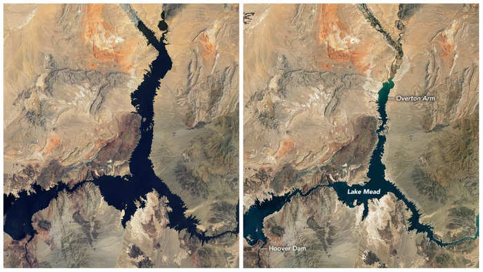
New satellite images released by NASA illustrate how Lake Mead's water levels have dramatically declined over the last 22 years.
"The largest reservoir in the United States supplies water to millions of people across seven states, tribal lands, and northern Mexico," the space agency said in a news release. "It now also provides a stark illustration of climate change and a long-term drought that may be the worst in the US West in 12 centuries."
Photos shared by the NASA Earth Observatory capture Lake Mead's thinning waterways in 2000, 2021, and 2022.
Side-by-side images of Lake Mead in 2000, 2021, and 2022.NASA
Even in the one-year span between 2021 and 2022, Lake Mead's waters shrank. Since January 2022, the lake lost more than 25 feet of water, according to water data from the Bureau of Reclamation. The agency predicts levels to drop another 20 feet by next summer.
Water levels are now at their lowest since the lake was filled in 1937, according to NASA.
Advertisement
As of July 25, water elevation at Lake Mead was at 1,040 feet. At full capacity, Lake Mead would be 1,220 feet deep near the dam and would hold 9.3 trillion gallons of water. The last time the lake approached full capacity was in 1999, NASA said.
Lake Mead, which straddles Nevada and Arizona, is a key reservoir that helps supply water to 25 million in the Southwest. Last year, government officials declared a water shortage in Lake Mead for the first time since its construction in the 1930s.
A buoy that reads "No Boats" lays on dry, cracked earth where water once was at Lake Mead, Nevada, on July 23, 2022.FREDERIC J. BROWN/AFP via Getty Images
The shrinking water levels have been linked to an decades-long drought that's gripped the Southwestern US.
A growing body of research attributes intensifying droughts to climate change. Rising global temperatures cause changes in precipitation and enhance evaporation. At Lake Mead, local precipitation and groundwater account for about 10% of the lake's water, according to NASA.
In recent months, Lake Mead's shrinking shores revealed long-submerged items, including human remains, sunken boats, and more.
Advertisement
{{}}
NewsletterSIMPLY PUT - where we join the dots to inform and inspire you. Sign up for a weekly brief collating many news items into one untangled thought delivered straight to your mailbox.


 Next Story
 US buys 81 Soviet-era combat aircraft from Russia's ally costing on average less than $20,000 each, report says
 2 states where home prices are falling because there are too many houses and not enough buyers
 A couple accidentally shipped their cat in an Amazon return package. It arrived safely 6 days later, hundreds of miles away.
 9 health benefits of drinking sugarcane juice in summer
 10 benefits of incorporating almond oil into your daily diet
 From heart health to detoxification: 10 reasons to eat beetroot
 Why did a NASA spacecraft suddenly start talking gibberish after more than 45 years of operation? What fixed it?
 ICICI Bank shares climb nearly 5% after Q4 earnings; mcap soars by ₹36,555.4 crore
