
Apple just released a tool that shows how well people in your area are staying home. Take a look.
Advertisement


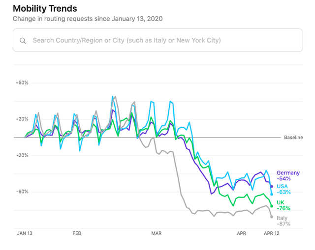
The tool lets you filter data by country, providing a breakdown of how much driving, walking, and transit has decreased in the past month.

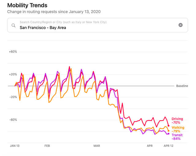
Apple also provides a breakdown of mobility data for some major cities, including San Francisco.
Advertisement
A comparison of different countries shows how early each nation enforced social distancing measures, and where they've been the most effective.
Apple has also published a full spreadsheet containing the raw data underlying the tool.

Apple insists that the location data is anonymized to protect users' privacy.
You can access the raw data here.
Advertisement
 Next Story
Advertisement
 A centenarian who starts her day with gentle exercise and loves walks shares 5 longevity tips, including staying single
  A couple accidentally shipped their cat in an Amazon return package. It arrived safely 6 days later, hundreds of miles away.
 FSSAI in process of collecting pan-India samples of Nestle's Cerelac baby cereals: CEO
 Indian economy remains in bright spot: Ministry of Finance
 A surprise visit: Tesla CEO Elon Musk heads to China after deferring India visit
 Unemployment among Indian youth is high, but it is transient: RBI MPC member
 Private Equity Investments
 Having an regional accent can be bad for your interviews, especially an Indian one: study
